
A CSO Frontier Series Output- What is this?
In this chapter, we use the data reported in 2019 by the National Parks and Wildlife Service under the Article 17 of the EU Directive on the Conservation of Habitats, Flora and Fauna (92/43/EEC) (hereafter Article 17 – EU Habitats Directive data) to map Annex I peatland and heathland habitats at national level and evaluate their condition. Table 3.1 below summarises the Annex I peatland and heathland habitats included in Article 17 – EU Habitats Directive data.
Table 3.1: Annex I peatland and heathland habitats included in Article 17 – EU Habitats Directive data | |||
|---|---|---|---|
| Peatlands/ Heathlands | Types of peatlands and heathlands | Article 17 - EU Habitats Directive data (as listed in Annex I) | Description1 |
| Peatlands | Raised bogs2 | Active raised bogs | Raised bogs characterised by the presence of an actively peat-forming upper layer whose surface is composed mainly of living bog mosses (Sphagnum spp.). |
| Degraded raised bogs | Raised bogs characterised by the complete absence (or patchy thin cover) of an actively peat-forming upper layer but still capable of regeneration after implementation of restoration works. | ||
| Blanket bogs (Atlantic and Mountain)2 | Blanket bogs | Areas of consistently high rainfall (>1,250mm and >225 rain days per annum) where the ground surface is waterlogged for much of the time, resulting in the development of deep peats. | |
| Rich fens | Alkaline fens | Fens with extensive areas of species-rich small sedge and brown moss communities. They occur in areas with a high water table and a base-rich, often calcareous water supply. | |
| Cladium fens | Fens with a vegetation cover mostly dominated by Cladium mariscus. | ||
| Petrifying springs | Lime-rich water sources where tufa is actively deposited and where characteristic species of bryophytes are dominant or abundant. Although classified as “Springs” in the Heritage Council Classification (Fossitt, 2000)3, they are classified as “Calcareous fens” in Annex I habitats. | ||
| Poor fens | Not included in Annex I of EU - Habitats Directive | Not included in Annex I of EU - Habitats Directive | |
| Transition mires and quaking bogs | Transition mires and quaking bogs | Physically unstable peat-forming communities, typically occurring as swards or floating mats over saturated peat or open water. | |
| Heathlands | Dry heaths | Dry heaths | Heathlands usually occurring on well-drained, nutrient-poor and acidic mineral soils or shallow peat soil (typically <50cm deep) on sloping ground. They merge into alpine and subalpine heathlands from 400m altitude. |
| Wet heaths | Wet heaths | Heathlands generally occurring on gently sloping, poorly draining ground on shallow or intermediate peat soil depth (>50cm). They are intermediate habitats between dry heath and blanket bogs. | |
| Montane heaths | Alpine and subalpine heath | Alpine and Boreal heath consists of two distinct subtypes in Ireland. The upland subtype occurs on the exposed summits and upper slopes of mountains on acidic substrate. The lowland subtype comprises Dryas heath on limestone. Alpine and subalpine heathland generally occurs from 400m altitude, below which they merge into dry heath. | |
| 1 As defined in the Article 17 reports - Volume 1 published by the National Parks and Wildlife Service4. | |||
| 2 Do not include highly drained, cutover and cutaway bogs6. | |||
The distributions of Annex I peatland and heathland habitats are displayed in Maps 3.1 and 3.2. Both ecosystems were mapped separately for presentation purposes. They might co-occur and form complex mosaics together. Degraded raised bogs and Petrifying springs were not mapped, as their spatial data were not at the same resolution as the other habitats.
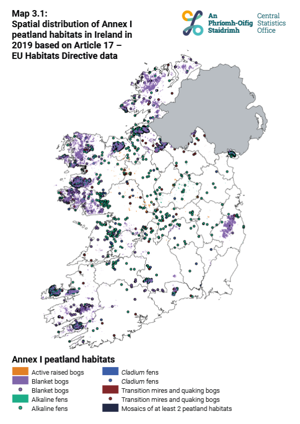
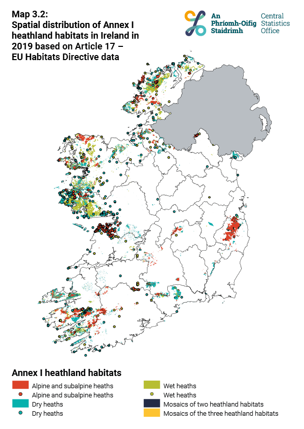
In Article 17 – EU Habitats Directive data, Annex I peatland and heathland habitats were mainly reported on the west coast, the midlands and the Wicklow Mountains in 2019 (Maps 3.1 and 3.2). These Annex I habitats occurred over an estimated 8% of the national territory. Fens and Raised bogs were mainly reported in the midlands while Blanket bogs, Wet heaths, Dry heaths and Alpine and subalpine heaths were observed on the west coast and in the Wicklow Mountains (Maps 3.1 and 3.2). Blanket bogs, Wet heaths and Dry heaths were the habitats with the largest areas reported under Article 17 – EU Habitats Directive in 2019 (Figure 3.1 and Table 3.2).
| X-axis label | Total area (hectares) |
|---|---|
| Blanket bogs | 257451 |
| Alkaline fens | 12531 |
| Transition mires and quaking bogs | 7741 |
| Cladium fens | 6971 |
| Degraded raised bogs | 2500 |
| Active raised bogs | 1659 |
| Petrifying springs | 14 |
| Wet heaths | 159851 |
| Dry heaths | 123001 |
| Alpine and subalpine heaths | 15074 |
Under Article 17 – EU Habitats Directive, the National Parks and Wildlife Service also reports the spatial extent of Annex I habitats protected by Special Areas of Conservation (SACs). For each Annex I peatland and heathland habitat, more than 45% of the known spatial extent occurred in SACs. Blanket bogs, Active raised bogs, Petrifying springs and Alpine and subalpine heaths have the largest protected areas (more than 60%, Figure 3.2 and Table 3.3)
| X-axis label | Not protected under SACs | Protected under SACs |
|---|---|---|
| Blanket bogs | 36.6 | 63.4 |
| Alkaline fens | 48.3 | 51.7 |
| Transition mires and quaking bogs | 41.5 | 58.5 |
| Cladium fens | 41.6 | 58.4 |
| Degraded raised bogs | 51.3 | 48.7 |
| Active raised bogs | 28 | 72 |
| Petrifying springs | 20 | 85.7 |
| Wet heaths | 49.2 | 50.8 |
| Dry heaths | 49.5 | 50.5 |
| Alpine and subalpine heaths | 22.9 | 77.1 |
Under Article 17 of the EU Habitats Directive, the National Parks and Wildlife Service reports the conservation status, at national level, of habitats listed in Annex I. It covers different aspects of habitats: the range (i.e. the total geographical area within which the habitat appears, and which is sufficiently large to allow the long-term survival of the habitat), the spatial area, and the structure and functions (i.e. includes an evaluation of the condition and the typical species). The worst assessment between range, area and structure and functions will define the overall conservation status of the habitat. The conservation status is calculated in relation to a reference value which corresponds at least to the value of the habitat assessment when the EU Habitats Directive came into force in 1994 (unless considered insufficient to ensure the long-term survival of the habitat). For more information, refer to the full National Parks and Wildlife Services reports using this link.
Including information on structural, functional and landscape characteristics, the conservation status is a good indicator of ecosystem condition. In this publication, we report all the aspects of the conservation status (i.e. range, spatial area, structure and functions) in 2019 associated with their short-term trend based on the last 12 years. Status and trend of conservation are categorised as follow4,6:
Table 3.4 - Categories of conservation status and trend as reported in Article 17 - EU Habitats Directives | |
|---|---|
| Status | Trend |
| Favourable | Improving |
| Inadequate | Stable |
| Bad | Deteriorating |
| Unknown | Unknown |
| Type of habitats | Favourable | Inadequate | Bad |
|---|---|---|---|
| Peatlands | 0 | 28.6 | 71.4 |
| Heathlands | 0 | 0 | 100 |
| Types of habitats | Improving | Stable | Deteriorating |
|---|---|---|---|
| Peatlands | 0 | 28.6 | 71.4 |
| Heathlands | 33.3 | 33.3 | 33.3 |
The overall conservation status of Annex I peatland and heathland habitats in 2019 is mostly Bad and Deteriorating (Figure 3.3 and 3.4). Raised bogs (active and degraded) are the most impacted and have Bad and Deteriorating status for Range, Area, Structure and functions and Overall status (Table 3.5).
Except for Raised bogs, all Annex I peatland and heathland habitats had a Favourable status under Range, while the status was Bad or Inadequate under Spatial extent and Structure and functions. Alpine and subalpine heaths was the only habitat with an Improving trend for every characteristic (Table 3.5).
| Table 3.5 - Conservation status and short-term trend of Annex I peatland and heathland habitats in Ireland in 2019 based on the Article 17 - EU Habitats Directive data | |||||
| Peatlands/heathlands | Annex I peatland and heathland habitats | Range | Spatial extent | Structure and function | Overall |
| Peatlands | Active raised bogs | Bad and Deteriorating | Bad and Deteriorating | Bad and Deteriorating | Bad and Deteriorating |
| Degraded raised bogs | Bad and Deteriorating | Bad and Deteriorating | Bad and Deteriorating | Bad and Deteriorating | |
| Blanket bogs | Favourable but Deteriorating | Inadequate and Deteriorating | Bad and Deteriorating | Bad and Deteriorating | |
| Alkaline fens | Favourable but Deteriorating | Inadequate and Deteriorating | Bad and Deteriorating | Bad and Deteriorating | |
| Cladium fens | Favourable and Stable | Inadequate and Stable | Inadequate and Stable | Inadequate and Stable | |
| Transition mires and quacking bogs | Favourable and Stable | Inadequate and Stable | Bad and Stable | Bad and Stable | |
| Petrifying springs | Favourable but Deteriorating | Favourable but Deteriorating | Inadequate and Deteriorating | Inadequate and Deteriorating | |
| Heathlands | Wet heaths | Favourable but Deteriorating | Inadequate and Deteriorating | Bad and Deteriorating | Bad and Deteriorating |
| Dry heaths | Favourable and Stable | Inadequate and Stable | Bad and Stable | Bad and Stable | |
| Alpine and subalpine heaths | Favourable but Improving | Inadequate but Improving | Bad but Improving | Bad but Improving | |
3. Fossitt, J. A. A guide to habitats in Ireland. (The Heritage Council, 2000).
4. The Status of EU Protected Habitats and Species in Ireland - Volume 1. (National Parks and Wildlife Service, 2019).
6. The Status of EU Protected Habitats and Species in Ireland - Volume 2. (National Parks and Wildlife Service, 2019).
Go to the next chapter: Restoration and Rehabilitation of Peatlands
Learn about our data and confidentiality safeguards, and the steps we take to produce statistics that can be trusted by all.