
This publication calculates the shortest distance by road from residential dwellings in the State to a set of remote work hubs and childcare services and is based on a matching exercise involving:
This exercise uses an origin-destination routing algorithm, within a Geographical Information System (GIS), which identified the nearest location of a particular service (either remote work hubs or childcare services) along the official road network for over 2 million dwellings on the Census 2016 dataset.
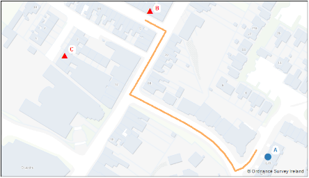
An example is shown below in Figure 1 and Figure 2 to explain the workings of the routing algorithm. Figure 1 shows the location of a residential dwelling at point A, and two points at B and C which represent a service (either remote work hubs or childcare services), as well as the outline of the OSi road network. The routing algorithm identifies the nearest service to the dwelling at A, which, in the example is point B, and then plots the shortest-path route and distance between A and B (marked orange in Figure 2).
Figure 1

Figure 2
The analysis outlined in this study was primarily concerned with measuring the distance to the nearest service, and that the level of service at a particular location was not considered.
The linkage and analysis was taken by CSO for statistical purposes under the Statistics Act 1993 and the CSO Data Protocol [1], and follows the international standard of statistical production outlined in the Generic Statistical Business Process Model (GSBPM) [2]
Census of Population 2016
As part of changes to the fieldwork first implemented in Census 2011 and continued for Census 2016, each household and dwelling was linked to geographical coordinates. This linkage has the benefit of offering flexibility in the production of census outputs for both existing and new boundaries, provided they are available in digital format.
In the case of 98% of dwellings on the Census 2016 geography dataset, this linkage was achieved using the national address database as the basis to conduct the enumeration of dwellings. The remaining 2% of dwellings enumerated was retrospectively digitised by census staff according to the location marked by enumerators on paper maps during census fieldwork activities.
Road network
The national mapping database (called PRIME 2) [3], is maintained by OSi and contains over 50 million attributed objects represented as either a point, line, or polygon. Each object has a form and function classification which describes the physical form (e.g. building) and its use (e.g. residential, hospital, church etc.). There are over 1,000 different function types recorded in PRIME 2. OSi gives access to the PRIME 2 database to public authorities for free under the National Mapping Agreement[4],
The central premise behind PRIME 2 is the ‘skin of the earth’ concept where topologically consistent objects cover the entire surface of the State. These objects are grouped into five broad categories; Way, Water, Vegetation, Artificial, and Exposed (non-vegetative ground such as sand and mud).
The road network used to produce the results in this publication are the centrelines of objects classified as ‘Way’ in the PRIME 2 database, and which has been simplified to international standards as Geographic Data Files level 2 (GDF2). A ‘Way’ is a generic term to describe all roads, streets, paths, and footpaths, while GDF2 are ‘Way’ segments simplified along certain parts of the network (i.e. around motorways, dual carriageways and roundabouts). There are over 300,000 distinct segments in the ‘Way’ GDF2 dataset, where each segment is a piece of the road network from one junction to the next. Each segment is seamless and forms part of a connected set of continuous segments with no unbroken lines or edges.
All road segments were treated equally, which means that the distances calculated by the routing algorithm reflect the ‘shortest-path’ route and not the ‘optimum-path’ route. The ‘optimum-path’ approach involves weighting the road network segments using additional attributes such as road type, speed limits, whether the road is one-way etc. It is intended to examine whether this approach can be developed further as part of future research.
In addition, the road network covers the jurisdiction of the State only. This may impact on the calculation of distances for dwellings along the border where using the Northern Ireland road network might be a more practical option for travelling to a particular service.
Remote Work Hubs
Remote work hubs are locations, other than homes or places of employment, where workers, start-up companies, and SME's can make use of facilities such as 'hot' desks in open-plan spaces, private offices, meeting rooms, collaborative spaces, and online meeting technology etc.
The locations of remote work hubs used in this analysis were taken from publicly-available data.
Access date - 9 February 2022
Childcare Services
The locations of childcare services used in this analysis were taken from publicly-available data.
Access date - 27 January 2022
National Address Database
Geocoding is the linking of location information, represented as an address or Eircode, to a coordinate value. As a result, the addresses or Eircodes of remote work hubs and childcare services were geocoded against the national address database, which contains the coordinates of over 2.3 million residential and commercial address points across the State.
It is important to stress that while efforts were made to check the data sources used in this publication, the responsibility for the maintenance of these sources rests with the providers who make their data available for public re-use.
The sum of row percentages in the tables in this report may not add to 100% due to rounding.
Settlements, Urban and Rural Areas
The Census definition of an urban area was used in this report.
A settlement has been defined since the 2011 Census as:
An existing settlement can be extended if there are newly created estates or dwellings within 100 metres of the original settlement boundary. The delineation of settlements happens after the processing of census results.
An urban area is a settlement with 1,500 people or more. Rural areas are defined as the population outside urban settlements and thus include towns with less than 1,500 people.
Counties and Cities
Under the Local Government Reform Act, 2001 (S.I. 591 of 2001), the areas formerly known as County Boroughs are now called Cities.
The country is divided into 31 administrative areas. Outside Dublin, there are 25 administrative counties and two cities, i.e. Cork and Galway. In Dublin, the four local authority areas are identified separately. (i.e. Dublin city and the three Administrative Counties of Dún Laoghaire-Rathdown, Fingal and South Dublin).
Section 9 of the Local Government Reform Act 2014 provided for the amalgamation of the city and county councils in Limerick and Waterford, and North Tipperary and South Tipperary County Councils. In this report, the amalgamated councils are called Limerick, Tipperary and Waterford.
The Local Government Act 2019 gave legal effect to the transfer of territory from Cork County Council to Cork City Council. This boundary change became operative on 31 May 2019. The data for Cork City Council and Cork County Council in this publication reflects the new boundary composition.
NUTS3 Regions
These regions are comprised as follows:
| Northern & Western NUTS2 Region | Southern NUTS2 Region | Eastern & Midland NUTS2 Region | ||||
|---|---|---|---|---|---|---|
| NUTS3 Regions |
Border | Cavan Donegal Leitrim Monaghan Sligo |
Mid-West | Clare Limerick Tipperary |
Dublin | Dublin City Dun Laoghaire-Rathdown Fingal South Dublin |
| South-East | Carlow Kilkenny Waterford Wexford |
Mid-East | Kildare Louth Meath Wicklow |
|||
| West | Galway Mayo Roscommon |
South-West | Cork Kerry |
Midland | Laois Longford Offaly Westmeath |
|
[2] Generic Statistical Business Process Model
Learn about our data and confidentiality safeguards, and the steps we take to produce statistics that can be trusted by all.